Cyclonic Storm “ROANU” moving towards Odisha

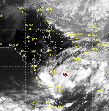 The cyclonic storm ‘ROANU’ over westcentral Bay of Bengal moved north-northeastwards at a speed of 10 kmph during past six hours and lay centred at 1730 hrs IST of today, the 19th May, 2016 near latitude 16.0º N and longitude 81.9 ºE, about 480 km southwest of Gopalpur.
The system is likely to move northeastwards along & off Andhra Pradesh and Odisha coast and intensify into a severe cyclonic storm by tomorrow morning. Continuing moving northeastwards, the system is likely to cross south Bangladesh coast between Khepupara and Cox’s Bazar in the night of 21st/ early morning of 22nd May as a cyclonic storm.
Forecast: Rain/Thundershower would occur at most places over South Odisha and at many places over North Odisha during next 24 hours.
Heavy R/F Warning: Heavy to very heavy rainfall is likely to occur at one or two places over South and Coastal Odisha on 19th May,2016.
Heavy to very heavy rainfall is likely to occur at a few places over Coastal Odisha on 20th May,2016.
Advice for hoisting Storm Warning Signals:
Distant Warning Signal Number Two (DW-II) kept hoisted at all ports in Odisha.
Likely impacts and actions:
(1) Gusty surface wind speed from Southeasterly direction in South Odisha Coast and Southerly direction in North Odisha Coast reaching 45 to 50 kmph with gusting to 55 kmph would prevail along and off Odisha Coast today. Sea condition is very likely to be high to very high along & off Odisha coast from night of 19th and also continue on 20th May,2016.
(2) Damage expected:
Damage to thatched huts, Minor damage to power and communication lines due to breaking of branches and Major damage to kutcha and minor damage to pucca roads over coastal Odisha.